
Ever since we started going up to the Seven Devils/Banner Elk area a couple of years ago, we have passed by the trail head for the Grandfather Mountain Profile Trail, and I have been waiting for my chance to go. The reviews online were a little confusing — one stating the trail was a little under 6 miles round trip, another stating it was over 11!
Well, we were up there again recently, and I got my chance. I had Kelly and the kids drop me off at the base of the trail. I knew I needed a permit, but I thought I might be able to get one at the base, and before I realized I could not, Kelly had driven off! The permits were just .7 miles up the road at an Exxon, so I began to run to it. About 1/2 way there, a lady I had seen and talked to at the based yelled from her car if I wanted a ride. It was kind of a dangerous place to stop, so I told her go up ahead of me to a pull out. By the time I got to her, it was only another couple tenths of a mile to the Exxon, but it was nice not to have to run all of the hill. I bought my permit for $5, got a map, and ran back to the start (all down-hill).
When most hikes are free, it may seem odd to pay $5 for the privilege. The cost goes into trail maintenance, and the trail is all on private property so there are no government funds like at state owned land. I can say that if all trails were this well maintained, I’d be happy to pay! There was almost no trash (I picked up the one piece I found), and the amount of work put into some of the stone work for stairs, erosion control, etc., was really amazing. Some of the stones that have been moved were just huge!
With map in hand, I realized why there was confusion in the trail distances… The “profile” trail is almost 3 miles up to the rest of the trail system on Grandfather Mountain, thus just under 6 miles round trip. Depending on what trails you take at the top, you can easily get to 12 miles or more. Looking at the map and all the trails, I had to make some decisions due to limited time. I decided to really push it and go for the swinging bridge, which was about 5 miles away. I had already gone about 1.5 miles to get my permit, and only had 4-5 hours total! I ended up running any of the flat sections or safe sections that I could. This was all good training for a 14,000-er attempt I hope to do in about 10 days in Colorado. (Though I am worried about how different the air at 14,000 will be than the 5500 most of this trail is at, it is the best training I could get here in NC.)
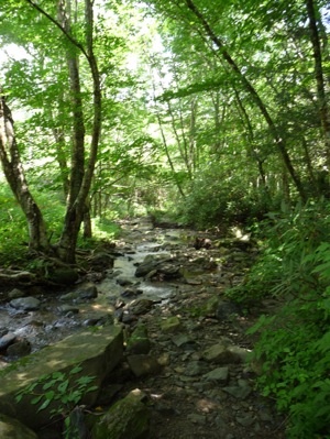
The beginning of the hike runs along highway 105 for a bit, and along a beautiful mountain stream.
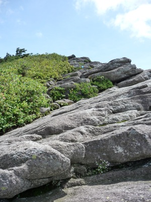
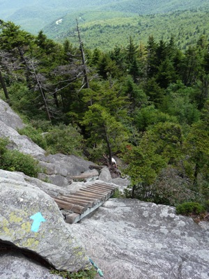
Once you turn up, you really go up — about 1700 feet in 2 miles, and parts of the trail are all rock:

That photo doesn’t do justice to the steepness — I guess they never do. And those rocks were really slippery, especially on the way down. I had forgotten my trekking polls, which made it that much worse.
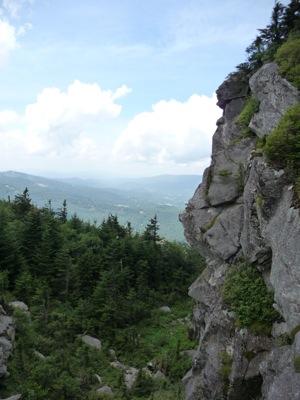
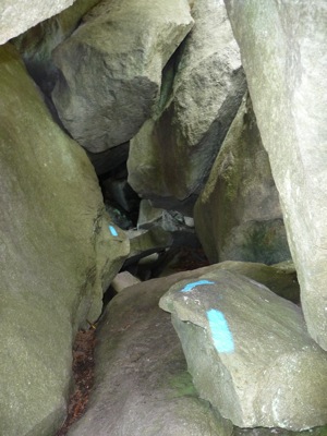
The hike became spectacular once getting off the profile trail, and hiking southwest towards the swinging bridge… About a half a mile or so on Grandfather Trail, and all of a sudden you are on top of all the rock formations that make Grandfather Mountain look like it does from the bottom. And the trail is literally on the ridge line, sometimes just feet from hundred foot (plus!) drops. There are cable runs, wooden ladders, and tunnels, as you can see in the photos below. This part of the trail had the most amazing views and rock formations I have seen since I hiked in Yosemite!


Yes, this is the trail… A ladder straight down, and then rocks (almost) straight down:

And then up a ridge:
And more down:
On the way up, there is one point where you can climb a ladder to McCrae Peak at 5939 feet, which has spectacular 360 degree views, where I took this video. The youtube quality is not great so some of the things I try to point out, you can’t really see. Oh, and later on, I found out the road on the backside is the blue ridge parkway.

Pingback: Bierstadt - Sawtooth - Evans « 2sparrows
Love this opinion. Maybe hiking gear should assist someone there.
Appreciated the opinion. Haven’t been to Grandfather from 105, only the expensive way. Another great climb for prep for Rockies is Old Butt Knob trail in the Shining Rock wilderness.
My friend and I are planning this same hike – ideally wanted to do profile and grandfather – is that too much for two middle aged/ok shape type of guys in one day?
thanks,
Jon
There are a lot of trails up there, so I’d want to make sure I understand exactly what you plan on doing. If you start at the bottom of 105, it is a 3 mile hike up about 2000 feet on miles 2-3, so that can be tough. From there it is about 3 miles the the mile high bridge. That section is by nature slow because of the ladders and cable runs and the like, as well as the steep little ascents and descents. I have Garmin data from April when I “ran” most of that:
http://connect.garmin.com/activity/29384684
It is hard to estimate time that it would take. I did it in just under 4 hours, but was running a significant portion. If you give yourself enough time, I certainly think a day hike is doable for a lot of people. Another option is to have someone meet you at the bridge.
Just did all the trails @ grandfather over july 4th. Profile is great, steep @ the top. I recommend the Underwood trail if headed west(avoid going down ladders) and the Grandfather trail option headed east(easier to climb 9 ladders).
It will take you all day but WELL worth the effort.
Great – I hope to do this next saturday….what is the deal w/ the permits…..do you have to do something ahead of time?
thanks,
jon
Permits are no longer required…
Pingback: 2010 in review « 2sparrows
Taking a group of guys up next month – I have done profile and it is a pretty tough climb up there to the swinging bridge and back….has anyone done the daniel boone scout trail from the other side to compare difficulty and time? I want to get these guys back home in one piece before dark…..thanks,
The back side is not much better — it is still a 2000 foot climb. Personally I think it is a bit easier. I’ve run up and over and back, starting on the Profile up to Calloway, then down Daniel Boone to Nuwati, up Cragway, back to Daniel Boone and back down the profile. I’ll post a GPS later…
And you didn’t jog down to the bridge while you were at it 🙂 hmmm… so seems like a draw as I think the Scout trail comes to craighead and requires the full trail along the ridge where profile cuts out the craighead peak. Maybe I’ll just stick with profile and get an early start. Thanks
I have “run” to the bridge and back after climbing the profile, but its much more of a slow hike than a run!
It’s tough to recommend one over the other… Cragway has spectacular views but there is just something about the profile that calls me…
Has the link to garmin gps data…